| Ken'ichi Okamoto |
 |
|
|
 |
 |
|
[Slide 7]
[Slide 8]
[Slide 9]
[Slide 10]
[Slide 11]
|
[Slide 7]
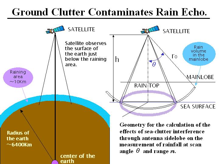
I will talk this ground clutter issue. Observation of rain by spaceborne precipitation radar is performed under the disadvantageous conditions. From the satellite, we observe rain firstly, and then observe ground just behind of rain. From the ground, far stronger scattered radiowaves come back, may be one million time sstronger than scattered radiowaves from rain. The radius of the earth is about 6400 km, but the raining area is only about 10 km deep. It is like having a 1 mm thin film on the surface of a watermelon with radius of 64 cm. Ignoring the influence of watermelon, we have to measure the 1 mm thin film. If you look up at the sky and measure the rain in the air from the ground radar, there is nothing but space just behind rain, so it is rather easy to measure the precipitation by the ground radar. If you look down from the satellite side, we had a difficult problem in eliminating the influence of the ground. When you look only nadir direction from the satellite, there might be small problems. However, when you observe the rain in the mainlobe at the off-nadir direction from the satellite, the ground could be observed simultaneously in the sidelobe. This sidelobe echo is called ground clutter. The scattering coefficients of the ground is about one million times stronger than that of rain, as I mentioned before, so we have to reduce sidelobe level by a factor of one thousandth.
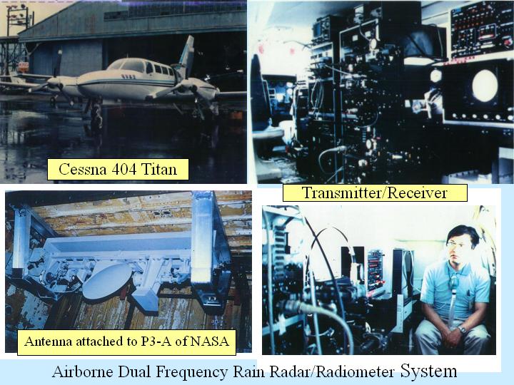
[Slide 8]
By the combination of short pulse and low sidelobe antenna characteristics, I thought based on the calculations that the influence of the sidelobe ground clutter could be suppressed. We successfully got the budget, therefore we developed airborne radar/radiometer system and did the experiment by airplane, as Dr. Fugono mentioned before. This slide show the antenna attached to the NASA P3-A airplane at the joint US-Japan airborne rainfall measurement experiment. This is an offset parabolic antenna. It had a good sidelobe characteristic and the mechanical scan was applied. Using 10 GHz and 35 GHz frequencies, we did the experiment. The aim of this experiment was to ascertain if we could suppress the influence of ground clutter by the combination of short pulse and low sidelobe antenna characteristics. To reduce the sidelobe level means that the antenna gain is also reduced. This causes the decrease of S/N ratio and the beam width becomes wide. Everything couldn't be improved at the same time. By using this type of antenna, we carried out the experiment to see if we could truly measure rainfall. This is myself, 25 years ago. As Dr. Fugono mentioned before, I am equipped with an oxygen mask. I seemed to be quite relieved, so I think I have just finished the experiment. I have done the experiment under these conditions. Dr. Fugono was a very gentle and nice manager. He always said if I felt terrible, I could get off the airplane at any time. However, he said if I came back without any data, I should be worrying about losing my life.
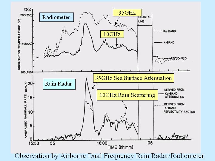
[Slide 9]
This airborne system was the combination of a precipitation radar and microwave radiometer. We thought it was very effective to measure rainfall simultaneously by using both the precipitation radar and the microwave radiometer. The results of this experiment demonstrated the effectiveness. The concept of loading the precipitation radar and microwave radiometer on the same satellite was actually realized in the TRMM. What I want to say about the upper panel is the high brightness temperature at 10 GHz. There is a strong correlation between high brightness temperature and strong rainfall rate. The lower panel shows the amount of average rainfall rate observed by 35 GHz precipitation radar. This value was obtained by using the sea surface echo attenuation by rain, not by the rain scattering. When it is raining, the radar wave is attenuated by the rain and weakened. When we use the sea surface scattering echo in rain, we can estimate the rain attenuation amount. From this attenuation amount, we can estimate the rainfall rate. In the theory it is easy to understand this. We have proved this by analyzing experimental data. The combination of the ground clutter, which gives a negative effect, and the rain attenuation, which also gives a negative effect, gives a positive result and a new algorithm is formed. This fact was demonstrated by the airplane experiments. This algorithm was brushed up by Prof. Nakamura of Nagoya University and Dr. Meneghini of NASA and Dr. Iguchi of CRL and is used in the TRMM precipitation radar algorithm as surface reference technique. Based on the experimental results, we had the strong feeling we could achieve a spaceborne precipitation radar.
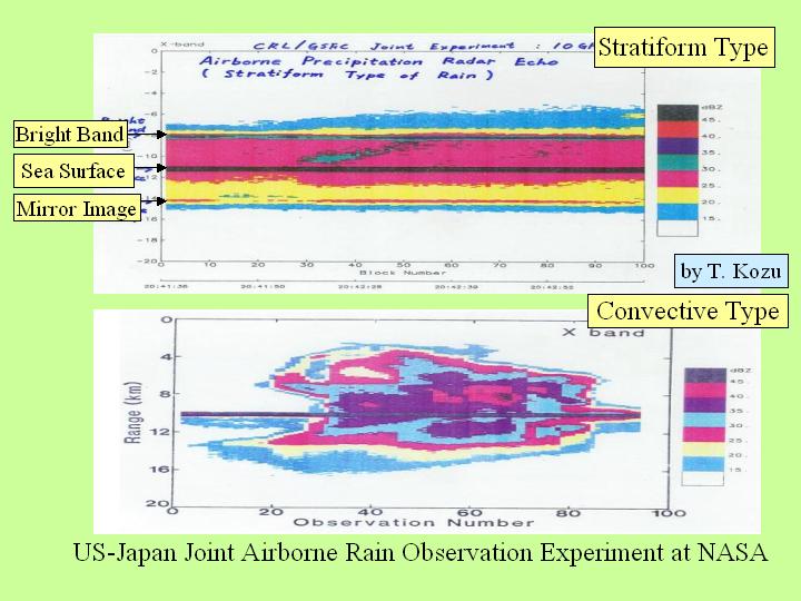
[Slide 10]
This slide shows the data obtained at the joint US and Japan airborne precipitation measurement experiment which was done during 1980s. Dr. Kozu, now at Shimane University, obtained this data. Very beautiful rainfall data were obtained from the NASA airplane. The top panel shows the stratiform type of rain and the bottom panel shows the convective type of rain, such as a thunderstorm. This part shows the melting layer, in which ice and snow are melting and can be clearly seen in this panel. The strongest echo area corresponds to the sea surface. Under the sea surface, the rain could be seen, but it shouldn't be occurring. The reflected wave from the sea surface was scattered by the rain and hit the sea surface again. It is a mirror image. The sea surface acts like a mirror. Not only the rain scattering, but also the sea surface attenuation and also the mirror image could be obtained independently. These data were found to be useful for analysis of rainfall rates. And the rain types were observed easily by radar, so we became quite confident of success. In summary, the merits of observation by spaceborne precipitation radar are presented as follows. The three dimensional structure of rain, especially vertical distribution of rainfall rate can be obtained by radar, which is impossible to obtain by using the other method. The microwave radiometer might be applied when the background is the uniform sea surface. However, it is very difficult to observe the rainfall over theland. The radar can observe the rainfall regardless of the background conditions, i.e. the land or the ocean. The integrated value of rain attenuation, as I mentioned before, can be obtained as an independent parameter. And both horizontal and vertical resolutions are very good.
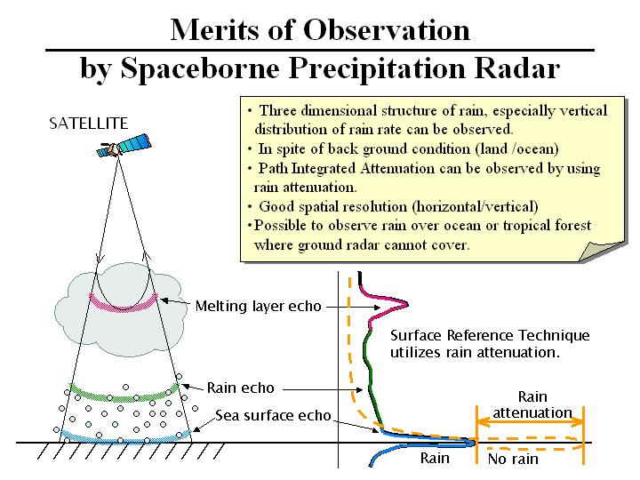
[Slide 11]
The radar echo profile is schematically drawn in this slide. From the satellite, melting layer, in which ice or snow exists, will be observed firstly. Under the melting layer it will be raining and then the ground will be observed. The orange dotted line shows the echo, when it isn't raining. The rain attenuation, which is the difference between the echo without raining and that with raining, can be obtained as an independent data in addition to the rain scattering data.
|
|
|