| Ken'ichi Okamoto |
 |
|
|
 |
 |
|
[Slide 23]
[Slide 24]
[Slide 25]
[Slide 26]
[Slide 27]
[Slide 28]
[Slide 29]
[Slide 30]
|
[Slide 23]
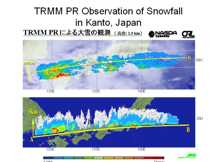
This slide shows the atmospheric depression passing along the Pacific side of the Japanese archipelago. The length of it was about 1500 km. The slide shows the distribution of rain in the western part of Japan and that of snow in the eastern part of Japan. These echoes were successfully observed.
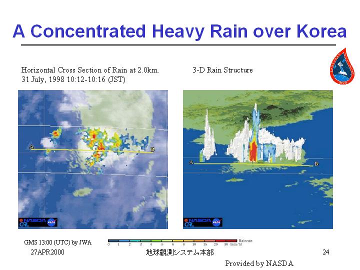
[Slide 24]
I have to skip and briefly explain this slide. This slide shows a concentrated heavy rain over southern Korea. This was observed in July 1998 and in the aftermath of El Nino. At that time, there still remained the effect of El Nino. The Yangtze River flood and the heavy rain in Niigata also occurred. In the Korea, they had the heaviest rain in the history. At that time several tens of mm of rain was seen in the slide and especially, in the southern part of Korea, 128 mm/h rain rate was observed. This storm system extended up to a height of 14 km.
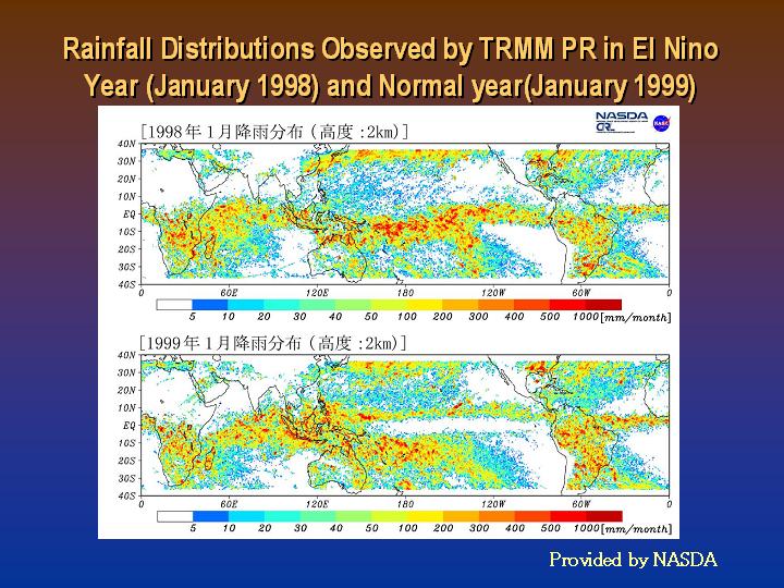
[Slide 25]
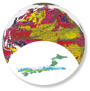
This slide shows, as Dr. Fugono mentioned before, the rainfall distributions observed by TRMM PR both in an El Nino year and in the normal year. (La Nina phenomena still remained.) When the El Nino phenomenon appears, heavy rain is observed in the central part of the Pacific Ocean. In a normal year, heavy rain is observed in the tropical area which is south of Japan. TRMM radar could clearly observe these different rainfall patterns
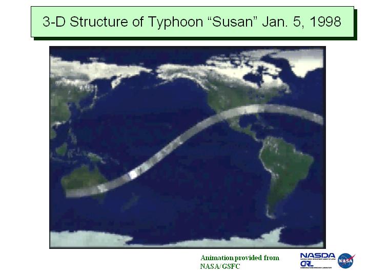
[Slide 26]
This slide shows the 3-D moving image compiled by NASA. The precipitation radar went through Typhoon "Susan" and got the rain distribution data under the cloud of "Susan." This is the sample of 3-D structure image. The US is moving forward in this technical field, but Japan is behind.
[Slide 27]
I will show you the image data of Hurricane Floyd. The PR radar went through the cloud of Hurricane Floyd and the 3-D distribution of the precipitation could be quantitatively observed. The TRMM precipitation radar was the first one in the world. This radar demonstrated that it was possible to obtain precipitation data and also to obtain good data for large meteorological systems.
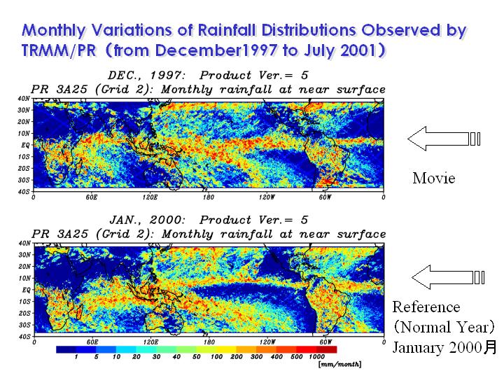
[Slide 28]
This is also movie image. The rainfall distributions of each month will be shown. This image shows the rainfall distribution on December 1997. It was in the middle of El Nino phenomena. The upper panel shows the pattern just after El Nino, and in the lower panel, the weak La Nina was observed. You can see the changes of rainfall every month. After the end of El Nino in Jun 1998, we can see the start of La Nina. Continuous patterns of each month will be shown. After the end of El Nino, La Nina phenomena started and continued. Thus the radar could observe the change of rainfall pattern every month. It became clear that the interaction between atmosphere and ocean causes El Nino phenomena.
[Slide 29]
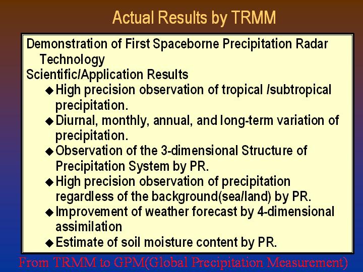
In summary I will show you the results of TRMM. The first spaceborne precipitation radar was launched and the capability of this technology to observe 3-D structure of precipitation was demonstrated. As for the scientific and application results, high precision observation of tropical and subtropical storm system was conducted. The diurnal, monthly, annual, and long-term variation of precipitation data could be obtained. The 4-dimensional assimilation using microwave radiometer was applied to the improvement of weather forecast. The weather forecast agency is beginning to use this data. The estimation of soil moisture content has been conducted by Prof. Oki of the University of Tokyo. The data obtained by TRMM has been used also for practical application fields.
[Slide 30]
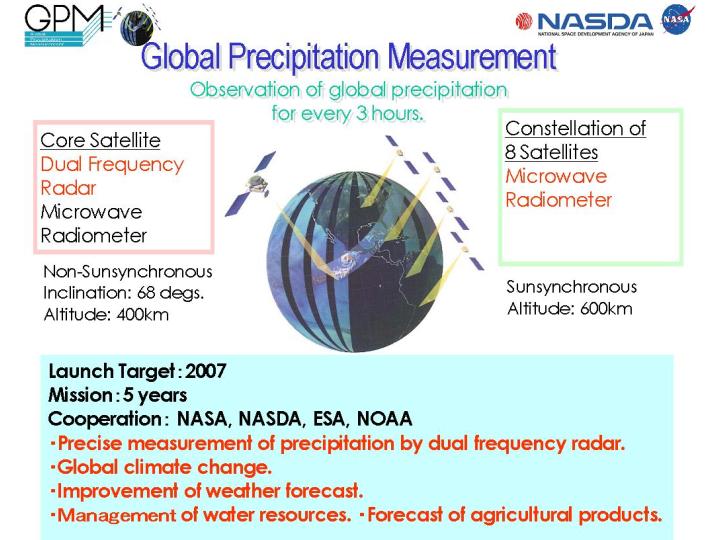
The results of TRMM will be transferred to the GPM, Global Precipitation Measurement. The aim of GPM is to observe the global precipitation for every 3 hours. The results will be applied to observe the global climate change, the relationship between the global warming and the precipitation, the improvement of weather forecast, the management of water resources and the forecast of agricultural products. Dual frequency radar, which was not achieved in TRMM, will be used and 8 small satellites with microwave radiometers will be launched. We have high expectation for GPM. As superior young scientists have come up in CRL and NASDA, I hope they surely make a success of this project. I will conclude my presentation. Thank you very much for your attention.
|
|
|